
 The Badrinath temple is situated near Joshimath in the Chamoli district on top of a hill. Traveling is a wonderful way to experience nature's beauty and spirituality. The roads are quite well constructed, and over time, connection to the temple has increased and improved as a result of the government of Uttarakhand's ongoing efforts and construction projects. With the help of roads, trains, and helicopter services, Badrinath is now well-prepared to handle the escalating flow of pilgrims. Here's how to complete this holy trip without any hassles if you're intending to do so as well:
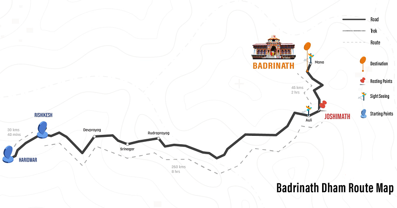
Location Between the Nar and Narayan mountain peaks, at a height of 3,415 meters above sea level, the sacred Divya Desam of Badri Vishal is set against the majestic Neelkanth Parvat. It is especially sacred since it is decorated along the Alaknanda River's banks, which subsequently join with the Mandakini River to form the Ganga, the holiest river in India. Some trekkers and adventurers stop here on their way to Auli or the Valley of Flowers or Hemkund Sahib, while others come as part of the revered Char Dham Yatra of Uttarakhand and India. How to Reach By Road - With a network of highways that connects Haridwar/Rishikesh, all the Prayags, and numerous hill towns in the Garhwal Himalayas, Kotdwar, and other locations, Badrinath is well linked. The jolly grant airport in Dehradun, which is 317 kilometers away from here, is the nearest airport to the Badrinath Dham shrine. From this point forward, people decide to use taxis or cab services. By Train - The Rishikesh Railway Station, which is 297 kilometers away from Badrinath Dham, is the closest, whereas Kotdwar Railway Station is 327 miles away from the revered shrine. Local buses may be found traveling to and from Rishikesh and Haridwar, but there aren't many trains that go through these areas. However, this is changing as more trains are now traveling through these areas and to other parts of India. By Helicopter - Online, you can easily find Badrinath Yatra by helicopter packages that take you to the holy temple via an exciting helicopter ride beginning at the Sahastradhara helipad in Dehradun, where the first flight takes place at 6:30 am and flows over the amazing Badrinath valley. The passenger gets discharged from the helicopter to the helipad next to the temple, which is only a few hundred meters away. Road Map with Directions and Distance Route 1: Haridwar / Rishikesh to Badrinath Haridwar → (24 km) Rishikesh → (71 km) Devprayag → (30 km) Kirtinagar → (4 km) Srinagar → (34 km) Rudraprayag → (20 km) Gauchar → (12 km) Karnaprayag → (20 km) Nandprayag → (11 km) Chamoli → (8 km) Birahi → (9 km) Pipalkoti → (5 km) Garur Ganga → (15 km) Helang → (14 km) Joshimath → (13 km) Vishnuprayag → (8 km) Govind Ghat → (3 km) Pandukeshwar → (10 km) Hanuman Chatti → (11 km) Badrinath Dham Route 2: Kedarnath to Badrinath (via Chopta) Guptkashi → (20 km) Ukhimath → (22 km) Dugalbitta → (7 km) Chopta → (27 km) Mandal → (8 km) Gopeshwar → (10 km) Chamoli → (96 km) Badrinath Dham Mandir Route 3: Kedarnath to Badrinath Kedarnath → (14 km) Gaurikund → (8 km) Sonprayag → (5 km) Rampur → (9 km) Phata → (14 km) Guptkashi → (7 km) Kund → (19 km) Augustmuni → (9 km) Tilwara → (8 km) Rudraprayag → (20 km) Gauchar → (12 km) Karnaprayag → (20 km) Nandprayag → (11 km) Chamoli → (8 km) Birahi → (9 km) Pipalkoti → (5 km) Garur Ganga → (15 km) Helang → (14 km) Joshimath → (13 km) Vishnuprayag → (8 km) Govindghat → (3 km) Pandukeshwar → (10 km) Hanuman Chatti → (11 km) Shri Badrinath Ji Mandir
0 Comments
Your comment will be posted after it is approved.
Leave a Reply. |
